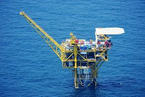
Amid news last week that over 200 Chinese fishing and coast guard vessels had swarmed the waters around Japan’s disputed Senkaku islands in the East China Sea, Japan’s Ministry of Foreign Affairs (MOFA) disclosed new evidence of possible Chinese militarization in the disputed waters. MOFA spokesmen said that one of China’s oil platforms in the East China Sea was found to have a military grade surface radar installed on it.
The only detail MOFA offered on the radar was that it was of a type “commonly found on patrol ships and not necessary for gas field development.” This implies the radar might have some military purpose in the middle of a sea where China and Japan are locked in dispute over the extent of their respective Exclusive Economic Zones (EEZ) and thus rights to the oil and gas reserves believed to be beneath it. Japan is understandably sensitive to developments that might threaten its EEZ claims in the region and lodged a diplomatic protest with Beijing over the radar last Friday. However, from photographs MOFA provided of Chinese oil platforms in the East China Sea and a map of their rough locations, it is hard to see what military advantage the radar would provide China, or even to be sure that it is not intended for civil use.
MOFA indicated that the platform in question is referred to as the “12th Structure” in its collection of imagery and maps and that the radar was located beneath the structure’s helicopter landing pad. From the photograph, the radar appears to be a large rotating slotted-wave guide antenna typical of navigational and surface search radars used in both civil and military applications, and not something more exotic with exclusively military use. Even if the antenna is military grade of the sort found on “patrol ships,” there is substantial overlap between civil and military radars of this type; even the surface search radar on most U.S. Navy destroyers, the A/N SPS-73, was based on a commercially available Furuno antenna. In other words, this Chinese radar may be found as commonly on patrol ships as it is on large merchant vessels, and is not obviously an exclusively military radar based on the images provided.
Many oil rigs are equipped with some type of surface search radar to provide awareness of approaching vessels, danger of collision, potential security threats like pirates, and to assist with helicopter operations. Furuno markets products specifically for oil platforms that work off of its large surface search radars, similar to those used by the U.S. Navy. Even if not strictly “necessary for gas field development,” such radars are not unusual on large platforms.
However, regardless of whether Structure 12 needs the radar or not, it is still capable of providing “dual use” military utility alongside its civil application for the platform. Assuming MOFA is correct and the radar represents militarization of China’s East China Sea platforms, it could be used to provide permanent surveillance of the disputed waters. But it would probably not see much. Last year Ankit Panda explained why these platforms posed little potential military threat, and noted that “gas platform-based radar facilities for military surveillance purposes would make little sense,” because China already conducted substantial ship-borne surveillance in the East China Sea. The map and likely ranges of this radar set help show why.
Furuno’s most powerful surface search radars have a nominal range of 120 nautical miles (nm), but this is best understood to be the maximum “zoom out” that the radar can display, not its expected detection ranges. Furuno estimates that surface radars can only detect targets at ranges about 6 percent beyond the visible horizon under most conditions. Though oil platforms are much taller than most ships and therefore have a longer horizon view, this still means Structure 12’s radar can likely only detect a warship-sized vessel 30 or 40 nm away.
Given Structure 12’s position in the northern end of the Chinese gas field, it could potentially provide early warning of vessels approaching China’s East Sea Fleet bases near Shanghai, or to vessels transiting from the Japanese home islands to the disputed Senkaku Islands to the south. But even if the radar’s range was double the horizon-estimate, an 80 nm detection range still does not give the platform enough reach to really provide much help there. Because the platform’s position is fixed, vessels that China may be interested in detecting and tracking can simply avoid the radar by a safe buffer while transiting in its vicinity. Vessels sailing between the Senkakus and the home islands probably wouldn’t even need to adjust their tracks. Then again, the radar might just be to help protect China’s East China Sea platforms from wayward fishermen and merchant vessels after all.


