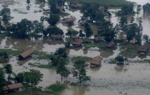
The Indian government has decided to implement a “consolidated strategy” to tackle floods and erosion in the frontier zone of the northeast, which is one of the most disaster-prone regions in Asia.
Topping the list in the new policy is a plan to set up the North East Water Management Authority (NEWMA) to facilitate a coordinated approach to check the twin dangers in the eight states of the region. The new agency will replace the Brahmaputra Board, which was set up in 1982 for the same purpose.
Giving details of the new plan, Assam Water Resources Minister Keshav Mahanta informed the state assembly that there were four attempts earlier to form a new agency in the northeast since the past several years, but they failed due to the opposition from other states in the region. He added that the entire process has been fast-tracked following an intervention by Prime Minister Narendra Modi. Assam has been the worst hit by flooding and erosion among all the states in the country. The Brahmaputra, the biggest river in the region, flows through the state with a total of forty-three tributaries on the north and south banks.
The Brahmaputra basin covers an area of 5,80,000 sq km, out of which 293,000 sq km is in China, 240,000 sq km in India and Bhutan, and 47,000 sq km in Bangladesh. The total annual flow of the Brahmaputra is about 573 BCM at Jogighopa in Assam on the Indo-Bangladesh border, which is 29 percent of the total surface flow of India. The river is unstable and has often changed its course due to the heavy deposition of silt, which has also resulted in braiding and meandering patterns in the alignment of the river system.
Almost 40 percent of the land in Assam is affected by floods and 10 percent of the flood prone areas in the country are in the state. An estimated 400,000 hectares of land have been lost due to erosion which amounts to eight per cent of the total land in the state. So far, 4,474 km of embankments and 642 sluice gates have been constructed besides 948 erosion-protection schemes that have been implemented in the last seven decades. The government has also applied for a loan of $700 million to the World Bank for similar projects to tackle flood and erosion.
The plan to set up the new agency and the stress on “coordinated approach” assumes importance against the backdrop of the limited success of the projects implemented earlier in the region, which were mostly short-term structural measures such as the construction of embankments, permeable and impermeable spurs, etc. These structures have often breached, causing flooding and devastation at regular intervals. Floods and erosion could also hamper the government’s long term plans for the region, which is seen as a bridge between South and Southeast Asia.
Meanwhile, the Brahmaputra Board has already begun implementing schemes, which are different from previous projects. The new strategy focuses on “soft measures” like the planting of certain categories of grass in the river banks, which are prone to erosion. They are aimed at preventing the rivers from accumulating extra silt, which raises the river bed with an adverse impact on the bank.
Officials were quoted by the media as saying that the planting of grass like Vetiver and some varieties of Hibiscus had earlier been done at Majuli with success and similar strategies had been adopted in certain regions of China and South Africa to check erosion.
Hard measures like engineering structure will also continue with the soft measures that are to be executed as part of the new approach. Ten new master plans are being designed for the projects and some earlier ones revised with new data which would also take into account the impact of climate change in the region. In addition, nine regional offices have been established in all the state capitals of the Northeast and Siliguri in north Bengal with the objective being to lay equal stress on all the tributaries of the major rivers.
Rajeev Bhattacharyya is a senior journalist in Assam, India.


