The primary aim of intelligence is to know the intentions and capabilities of adversaries to ensure a state’s security. However due to the sensitive and resource-intensive nature of intelligence collection, it can also function as a confidence-building measure between states. Given the growing prominence of the Indo-Pacific region in the United States’ national security priorities, is the time ripe for the U.S. to formalize an intelligence-sharing network with Quad partners Australia, Japan, and India?
A Patchwork of Quadrilateral Intelligence Capabilities
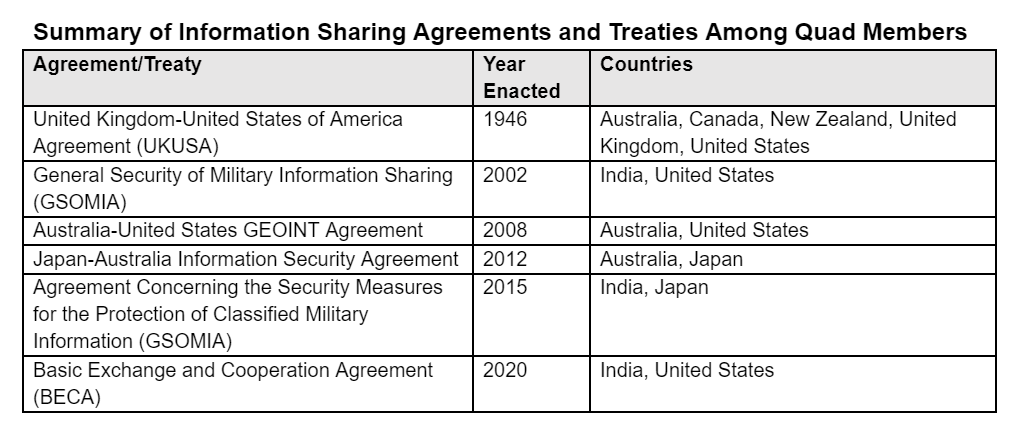
The United States provides gradations of intelligence sharing with its allies and partners, the deepest ties being to Britain, Australia, and Canada built on the UKUSA treaty — the foundation of the Five Eyes network — for cooperation in signals intelligence (SIGINT). In addition to its SIGINT agreement, in 2008 the U.S. and Australia signed an agreement for “intensified co-operation and intelligence sharing in the field of GEOINT – geospatial intelligence,” where the U.S. provided support for Australia to obtain an imagery satellite through which Australia could gather information that it would share with the U.S. and its allies.
While not a member of Five Eyes, Japan as a U.S. treaty partner has established bilateral defense intelligence sharing. Beyond this, Japan signed the Japan-Australia Information Security Agreement in 2012, which “lays the foundation for information sharing and information cooperation between Japan and Australia, and is expected to further strengthen Japan-Australia security cooperation.” In 2020 Japan expanded its state secrets law to broaden the scope of its defense intelligence sharing beyond the U.S. to include Australia, India, Britain, and France, to promote broader cooperation as well as joint developments of defense equipment.
India has also made efforts to ramp up its intelligence sharing capabilities with other Quad states, despite lacking an alliance with any of them. It signed General Security of Military Information Agreements (GSOMIA) with the United States and Japan, but of particular importance was the 2020 signing of the Basic Exchange and Cooperation Agreement for Geospatial Cooperation (BECA) between India and the United States. Going beyond other agreements that enabled military logistics and secure communications, BECA strengthens India’s ability to collect, process and produce GEOINT data, further enabling interoperability among Quad states.

Toward a Quadrilateral GEOINT network?
Clearly the Quad states have made inroads in formalizing intelligence sharing through GEOINT, but perhaps this isn’t surprising given the critical role it has played since the Quad’s inception. Following the 2004 Indian Ocean tsunami, the U.S. National Geospatial-Intelligence Agency (NGA) harnessed its collection and analysis assets to provide timely information to responders. NGA assessments also provided the framework for the U.S. response to Japan’s 2011 triple disaster. With its ability to greatly enhance humanitarian assistance and disaster relief (HA/DR) operations, GEOINT likely provided Quad states the means — during a crisis — to build trust. As U.S. intelligence expert Mark Lowenthal notes in his book, “Intelligence: From Secrets to Policy,” “exchanging useful intelligence is a good way for nations to build confidence in one another.”
Of course, states must prioritize safeguarding the integrity of their intelligence sources and methods, but under appropriate circumstances intelligence sharing can advance common objectives, particularly in a rapidly changing security environment where retaining primacy in collecting, processing, and analyzing information is a Sisyphean task, even for the U.S.
Despite the progress, two main challenges remain for the Quad’s intelligence sharing. The first has to do with incongruent national intelligence systems, or rather “dissimilar information platforms and national classification of intelligence products.” While the former issue is somewhat nullified in the Quad’s GEOINT developments since U.S. technology (satellites) is primarily relied upon, the latter concern is one that needs continuous effort. However, these issues of interoperability are likely to be overcome in the medium term with focused efforts to address their shortcomings.
The larger challenge to formalizing a Quad intelligence-network is China. China’s perception of the Quad as a counterbalance to its position as a leader in the Indo-Pacific is one that the Quad states take seriously. They have refrained from openly naming China as a common threat and rationale for their collaboration; however, their alignment on preserving a “free and open Indo-Pacific” underscores their concerns about deterring coercive behavior, particularly in the maritime domain. This will likely prevent public acknowledgement of any formal Quad mechanisms with national security implications, but it shouldn’t slow the integration of Quad GEOINT capabilities.
While SIGINT can be viewed as particularly intrusive by target states, the growth of commercial GEOINT has democratized access to imagery. Indeed, satellite imagery can support intelligence gathering like tracking troop and fleet movements, of key concern to India and Japan, who watch China’s movements closely. But GEOINT provides users with information critical to non-traditional defense missions as well, those related to climate change, IUU fishing, mass migration, HA/DR, and pandemic mitigation, a growing set of threats on the horizon that will also affect China.


