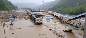
While a vast part of India continues to sizzle under excessive heat, the country’s northeast has been devastated by floods and landslides again, with as many as five states being adversely impacted due to incessant rains for the past two weeks.
Assam has been the worst affected with at least nine people dead and nearly 0.7 million people affected across 27 districts in the state. Around 48,000 people who were compelled to leave their homes have been shifted to 248 relief camps established by the government.
The hill district of Dima Hasao and Cachar in the southern part of the state are the worst-affected with massive landslides at several locations that have completely ruptured the rail network. The deluge has derailed trains at Haflong railway station and tunnels through the hills are under water. The railways have stated in a report that the landslides across the Lumding – Badarpur hill section at Dima Hasao has completely disrupted rail communication with the border states of Tripura, Manipur and Mizoram since May 14.
The worsening situation prompted the government to deploy the Indian Army and Assam Rifles to carry out rescue operations in Cachar.
An official said that the Tripura government has prepared a contingency plan for supply of essential items by road from Assam as restoration of the railway network that has been thrown out of gear by landslides in the neighboring state will take at least two months.
Landslides have wreaked havoc in Arunachal Pradesh and Meghalaya as well, snapping road links in many areas. Rivers in Manipur were reported to have risen to touch the danger level. Several districts in the state are submerged under water.
Normal flow of traffic has been disrupted across Assam due to waterlogging.
On May 9, the Indian Meteorological Department warned that the cyclonic storm Asani could result in widespread pre-monsoon showers with thunderstorms, lightning and gusty winds in several states of the northeast.
Weather experts told the media that the moisture incursion from the Bay of Bengal due to strong lower-level southerly and south-westerly winds have caused the abnormally high rainfall over the past several days.
Although flooding is a recurring phenomenon in the country’s Northeast and especially in Assam, the destruction witnessed in Dima Hasao is unprecedented. It was only seven years ago that the railways had completed the project to connect the hill district with the rest of the country through a broad gauge network. The network erected during the colonial regime was then abandoned.
In 2010, an audit by the government drew attention to the faulty construction undertaken by the railways in Dima Hasao. It pinned the blame on “unreliable soil strata” and the “trial and error” approach adopted for the project, which also resulted in an unproductive expenditure of around $116 million.
As it appears, the railways did not pay attention to the report.
The current condition of the rail network in the hill district and the impact of floods in the border states are stark reflections of the manner in which some vital projects are implemented in the country. It also points yet again to the government’s lack of preparedness to tackle such calamities.
India’s Northeast is envisaged as a “new growth engine” and a bridge between South and Southeast Asia. Projects have been planned to link the landlocked region with the neighboring countries of Bangladesh and Myanmar.
The ongoing floods is a grim reminder of the erratic rainfall pattern that the Northeast has undergone over the past several years, which is also indicative of climate change similar to other parts of the country. The region has received less rainfall than normal in the recent past and the distribution pattern was noticed to be skewed.
What makes the situation more perilous in India’s Northeast is that it is also part of the Indo-Burma Biodiversity Hotspot that extends to parts of Southeast Asia. India has a total of six such hotspots spread across different states.


