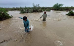
When heavy rains and flooding inundated thousands of houses across Balochistan this summer, Farzana (name changed) and her family had no option but to evacuate their home before the floodwater washed it away. They had lived in Bela, in Baluchistan’s Lasbela district, for as far as they remember. But they have never experienced the kind of rains and vulnerability they saw recently.
“Four of our rooms, countless neighboring houses, shops, the neighborhood mosque and the madrassa [a religious school], indeed many villages were completely destroyed and submerged under muddied water. We somehow managed to evacuate but we have nothing now. Not even a roof over our head,” Farzana told WANG, a local organization in Lasbela.
While thousands of people across Pakistan have suffered on account of heavy rains and flooding, people in Balochistan, the country’s poorest province with minimum infrastructure and where the majority of people in villages and towns live in mud houses, have been the worst affected.
According to the National Disaster Management Authority (NDMA), more than 36,469 houses were destroyed across Pakistan — 60 percent of them were in Balochistan. Around 800 schools were affected due to the floods, 600 in Balochistan alone.
According to the World Food Program about 571 people lost their lives in the floods across the country. Of every 10, three casualties were in Balochistan, the largest number in any province. Thousands of acres of crops and vegetation ready for harvest were destroyed, over 2,000 acres in Lasbela district alone.
Even as floods were ravaging Balochistan, the province was hit by another natural disaster, this time an earthquake at the end of July. Although no casualties were reported, several houses were destroyed partially and completely in Pasni, a coastal town in Gwadar district.
Since the floods, several villages across Balochistan are cut off and are still not reachable as roads and bridges were washed away.
Among several others, two important road links that the rains destroyed were the main RCD (Regional Cooperation for Development) Highway that links Pakistan’s commercial capital of Karachi with Balochistan’s capital Quetta, and the Makran Coastal Highway, which links southern Balochistan, especially the Gwadar Port, with Karachi and rest of the country. These roads are important not only for travel but also for bringing in food and other supplies to Balochistan.
Although the rains in the last two months have been the worst in 30 years, submerging of roads and bridges is not new to the region. Many parts of these roads and bridges are easily washed away after every seasonal rain, let alone heavy rains and flash floods. They are restored temporarily again and again, without a permanent solution.
Balochistan receives the lowest annual rainfall in Pakistan. This is a region where dry, arid weather and droughts are normal. Rain and floods of the magnitude witnessed lately point to an alarming climate crisis. According to a report by the German Watch Institute, a non-profit that works on climate change issues, Pakistan is the eighth most affected country in the Climate Risk Index since 2000.
Climate change has increased the risk of floods. In addition, Balochistan which is situated in one of the world’s most active seismic zones is at constant risk of earthquakes.
Amid the ongoing climate crisis, the frequency of hazards like floods will probably increase. However, the devastation resulting from such hazards will be magnified by poor infrastructure, unprotected housing, and a missing disaster management system. This is evident in Pakistan. Statistics from Balochistan confirm that natural hazards become even more deadly when they hit the most vulnerable.
However, it is possible to reduce the risk and damage such disasters bring through measures such as setting up an early warning system.
Although Pakistan has institutional structures like the National Disaster Management Authority (NDMA) at the federal level and the Provincial Disaster Management Authorities (PDMAs) at the provincial level, disaster preparedness has never been a priority.
Pakistan’s National Climate Change Policy does mention the need to put in place early warning systems; evacuation plans and strategies; ensuring reconstruction of rural housing to reduce risks of floods; and construction of disaster-resilient hospitals, dispensaries, and strong school buildings to be used as designated safe shelters.
But none of these plans was ever implemented. In fact, school buildings were one of the first to collapse with the gushing flood waters.
When weather forecasts predict heavy rains that could cause flooding, it is the responsibility of national and provincial institutions to prepare for possible risks. But that has not happened. Villages most affected by the flooding hardly have access to advance information. People living in these villages only left their mud houses when they estimated possible flooding after heavy rains continued for days. Even when they left, they had no safe place to go and were left under an open sky.
In addition to the NDMA and the PDMA, there are several government departments whose ambits touch on disaster-related issues, like those dealing with forestry, irrigation, and public health and engineering, as well as national and international development organizations. While having different responsibilities, these departments are closely interlinked with each other. Efficient coordination and planning between these institutions are key to minimizing risks and loss.


