Residents of Dibrugarh in the Indian border state of Assam were again overwhelmed with fear recently over the twin threats of flood and erosion that have haunted the district continuously for the past several decades.
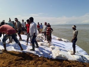
In early October, eight houses were washed away following severe erosion by the Brahmaputra River at Maijan-Nagakhuli in the district, triggering hectic efforts by the government to repair the damaged embankment.
A bigger disaster was averted for the time being with the construction of a dowel-like bund and by placing soil-filled geo fiber bags along the vulnerable zone In addition, there will be concrete porcupines at the site to lessen the intensity of erosion in the embankment.
Located about 450 kilometers east of Assam’s capital Guwahati, Dibrugarh is one of the districts that is worst affected by flood and erosion in the state.
Since 1956, several preventive measures have been implemented in Dibrugarh city and the district, including the construction of land dykes, stone and timber spurs, a 10-kilometer-long dyke from Maijan Mothola to Mohanaghat and Bogibeel, and a 22-kilometer-long drain crisscrossing the city.
All these measures have proved inadequate in checking the twin dangers that loom large over the district. Dibrugarh deputy commissioner Biswajit Pegu told the media that the breach at Maijan was caused by the changing course of the Brahmaputra River. Consequently, Maijan was impacted instead of Rohmoria located north of the city which had faced the brunt earlier.
A report compiled by the Asian Development Bank on Dibrugarh explained that “Although the protection of Dibrugarh town from erosion of the Brahmaputra River that started in the 1960s is rightly being claimed to be a success story, yet over the years the problem resurfaces itself in new forms as the river configuration vis-à-vis the adjoining river bank areas have changed considerably and reach upstream and downstream of the town are being affected by chronic erosion hazards eating away large chunks of productive tea cultivated lands.”
An interplay of many factors has contributed to the perilous state of affairs in the district. Dibrugarh is a mix of flood plains, lakes, swamps, sandbars and highlands. The location of the district is such that it remains exposed to mainstream flooding from the Brahmaputra River, tributary flooding from both Maijan Beel (a lake located north of the city) and the Buridehingmukh River (to the south of the city), and local flooding from heavy rains.
Occasionally, all the factors have combined to cause massive floods in the region. Areas that were tea plantations have been subjected to erosion and inundation by the floods. The conditions in the city have been aggravated by poor drainage and the inadequate sluice outlet in Maijan Beel.
Over the past many decades, it is estimated that the flood levels at Dibrugarh have increased seemingly at a constant rate of 0.33 meters per decade because of periodical slugs of sediment load resulting in overall aggradation of the riverbed. Consequently, the capacity of the river to hold water has reduced over the years.
Many observers feel that the devastating earthquake of 1950 caused the Brahmaputra river to change its course in many parts of the state resulting in more flooding and erosion in the subsequent decades.
In Dibrugarh, the northeastern stretch was drained by the Dibru River, a tributary of the Brahmaputra with its confluence about 18 kilometers east of the city. However, due to the raising of the river bed after the earthquake, the Dibru River merged with the Brahmaputra. Currently, the Maijan channel, which was a tributary of the former Dibru River, also joins the Brahmaputra River through a narrow opening.
A government official in the water resources department claimed that many zones in the state prone to flood and erosion have been identified for the implementation of long-term measures. He added that a scheme on Dibrugarh would be submitted as well to the Asian Development Bank for an embankment along a 15 kilometers stretch considered vulnerable with a high possibility of being breached during the monsoon.


